


Castro da Cidá
About this heritage
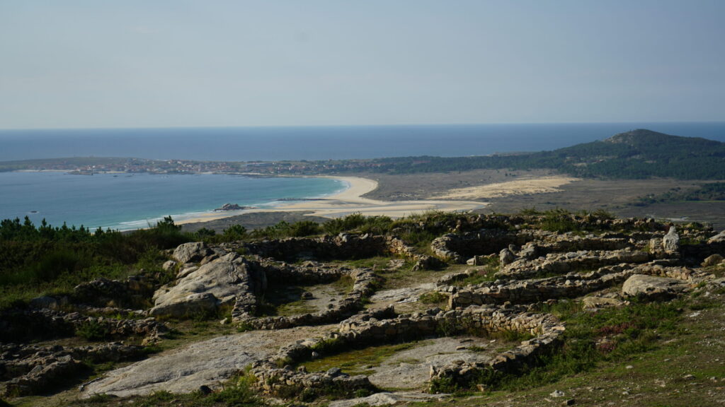
Castro da Cidá is located at the westernmost tip of the Barbanza peninsula, on a small mountain with an altitude of 210 meters. This hill, due to its panoramic views, became a strategic location. From it, you can observe the Ría de Arousa, Cabo Corrubedo, its town, and the Parque Natural do Complexo dunar de Corrubedo, lagoas de Carregal e Vixán. More than 2500 years ago, it was chosen as the settlement for a community belonging to the castreña culture. The occupied archaeological complex extends over about 20,000 square meters. It is one of the oldest castros in Galicia, dating from the Iron Age, structured around a small natural oval enclosure measuring approximately 98 x 65 meters. It is surrounded by two walls encircling a village and a third partial outer wall located at the most defensively vulnerable access point. At the highest level, there are parts of circular and square-shaped dwellings. This fortification is perfectly protected from external attacks. On one side, its north and west faces have embankments that make ascending this acropolis very difficult. On the east and south sides, it is flanked by natural rocks acting as a defensive wall.
At the highest part of the mountain, near the geodetic vertex, a large rock with several potholes and channels can be observed. It is believed they may have had a sacred and ritual past.
All access doors of these constructions face a central space, suggesting a possible construction with a studied urban layout. Archaeologists highlight the absence of "lareiras" (hearths), cooking ovens, and utensils typical of daily life, leading them to suppose it was an artisanal area within the castro.
Additionally, a more modern construction has been found that takes advantage of the foundation of two Galician huts. This corresponds to a watchtower used to monitor navigation against the British naval threat and dates from the late 18th century. Among the items found, the greatest discovery was five glass paste beads, which archaeologists believe were part of a necklace or bracelet.
Below the castro, to the west, rises the rock known as Pedra de A Rá (the Frog). A viewpoint has been built on it to observe the best panoramas of the entrance to the mouth of the Ría de Arousa, as well as the island of Sálvora and much of the Parque Natural do Complexo dunar de Corrubedo, lagoas de Carregal e Vixán, in addition to its town and the cape that bears its name.
To learn more
Castro de A Cidá is located between the parishes of San Xián de Artes and San Paio de Carreira, in the municipality of Ribeira (A Coruña). The remains of the castro on the hill of A Cidá are found right at its summit. The name "Cidá" comes from the Galician word "cidade", which translates to "city" in Spanish. It is an Iron Age complex surrounded by three lines of walls, where, at the highest level, both square and circular dwellings are combined. It also had an area designated for industrial use. The complex covers an area of about 20,000 square meters. Currently, a small part is excavated and adapted for free visits. The defensive structure of this castro took advantage of the terrain's natural shape. Located at the very summit, it had an unbeatable defensive position, making access difficult. To achieve this, they used, on one hand, the slope and embankment surrounding it, and on the other, a rock enclosure measuring 100 x 60 centimeters.
Being very close to the coast, it is possible that this "city" may have had commercial relations with other civilizations arriving from the peninsula and the Mediterranean. Between April and May 2014, excavations were carried out in the highest area of this hill, resulting in the discovery of about fifteen dwellings from the castreña period, scattered over an area of 450 meters. These remains lead archaeologists to believe that about one hundred people could have lived in this place. Additionally, 600 pieces were collected for study, indicating the existence of ceramics, metallurgy, and textile industry. Excavations continued in 2015, along with consolidation and conservation work on the archaeological structures.
To know it better
The Castro de A Cidá is located in the municipality of Ribeira, in the province of A Coruña. More specifically, it is situated between the parishes of San Xián de Artes and San Paio de Carreira. To talk about castros, one must go back to the Bronze Age (7th century BC) and imagine what life was like thousands of years ago. These fortifications were the settlements where the Celts lived. Their shape could vary between oval or circular and they were usually established in elevated areas.
The castrense settlement is located on Monte da Cidá or Cibdá and was inhabited between the 6th century BC and 1st century AD. Over the years, the constructions wore down, but in 1924 they were discovered. This led to the beginning of archaeological work and excavation in 1932. In 2014, thanks to a series of excavations in the highest area, about fifteen dwellings from the castro period and a more modern construction were discovered. On the same hill, very close to the Castro de A Cidá, is the Pedra da Rá viewpoint, which has been used as such since the 1980s. Its name comes from the frog-shaped figure shown on the rock at the viewpoint. From this point, one can observe the entire Atlantic Ocean, as well as a large part of the Natural Park in which part of Corrubedo is integrated.
The Natural Park covers nearly 1,000 hectares. It is made up of dunes, Corrubedo beach, and the Vixán lagoon, which is freshwater, and the Carregal lagoon, which is saltwater. In it, species such as birds and otters can be observed.
Location
- Town
- Ribeira
- Municipality
- Ribeira
- Province
- A Coruña
- Country
- Spain
The asset
- Type
- Castro
- Eco-destination
- Ría de Arousa
- Environment
- Natural
- Relevance
- International
How to get there
- Access
- By sea By land
- Distance
- 5 km
The visit
- Visitable
- Yes
- Accessible
- No
- Parking
- No
Coordinates
- Latitud
- 42.56131900
- Longitud
- -9.01366100