


Coto da Filloa
About this heritage
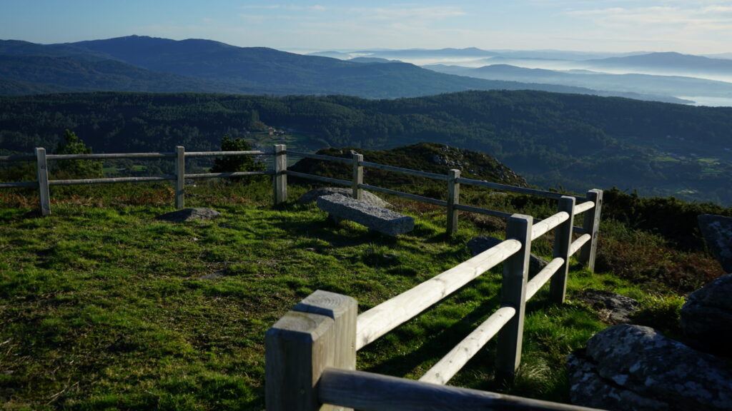
Ten kilometers from Boiro is the viewpoint of Figueira, also known as "Coto da Filloa." The word "coto," in this case, refers to the highest part of a mountain, which generally has a conical shape and makes it vertical. This viewpoint is in a location called Figueira in the parish of Cures, Santo André.
From here, anyone can enjoy the panoramic view of the Arousa estuary, with the mussel rafts perfectly aligned. In front, one can see Vilagarcía de Arousa, with Arousa Island right in the middle of the estuary, and closing the southern part, the peninsula of O Grove and the small rocky island of Pombeiro, where the waves crash. Protecting the estuary is Sálvora Island with the Noro, Vionta, and Herboso islets, forming a unique landscape. On clear days, visitors can also see the Ons Islands to the south, the Cíes Archipelago, and even Santa Trega Mount, which stands at the mouth of the Miño River, making a natural border with Portugal. In this place, everyone can enjoy the presence of wild horses.
Near this enclave is the the "Route of the Mamoas," or stone tumulus, an artificial mound that covers a dolmen chamber, formed by about 30 funeral monuments that date back thousands of years. This location would be an excellent place to watch over the territory, to get their bearings, and to defend their families.
To learn more
The Figueira viewpoint, also called "Coto da Filloa," is at the top of a mountain, a few kilometers from Boiro. This enclave, which belongs to the parish of Cures, Santo André, offers impressive panoramic views of the Arousa estuary.
The "mamoas" route or megalithic route, referring to a necropolis, which forms a natural transit route, are other elements close to the parish of Cures. It allows anyone to cross the interior of the Barbanza Mountain Ridge following what was, around 6000 years ago, a ceremonial route with more than 30 "mamoas." They used grave mounds to bury different people, regardless of gender or age, along with their belongings, tools, and ornaments. They sought to create landmarks to impose the presence of those who built them in the most transited areas. Maybe, that is why they chose the Barbanza Mountain Ridge since it was and is a natural passage zone to cross the peninsula.
The "Coto da Filloa" or "Filloa" viewpoint is one of the lookout sites that anyone can observe from the sea when taking "The Route of the Sea of Arousa and Ulla River." A unique maritime-fluvial route to commemorate the arrival by sea to Galicia of the remains of the Saint James the Apostle (Saint James the Great) after his martyrdom in Jerusalem in 44 BC. Known as the "Traslatio," this route constitutes the only maritime “Way of the Cross” (Via Crucis) in the world.
To know it better
Boiro is a coastal municipality in the Barbanza region in the province of Coruña. This municipality of the Southern Estuaries (Rías Baixas, bathed by the Arousa estuary, has a large variety of beaches, such as those of Carragueiros and Barraña. Likewise, one of the most popular coastal visits in the area is the Cabo de Cruz (Cross Cape) and the Barraña cove. It is also close to towns, such as Pobra do Caramiñal, Rianxo, and Ribera.
In the Boira parish of Cures is the village of Figueira. Here, anyone can enjoy nature and a spectacular view from the "Coto da Filloa" viewpoint, known also as the Figueira viewpoint. Surrounded by rocks and bushes, this place offers views of the entire Arousa Estuary.
Near the viewpoint, the famous “mamoas,” or stone tumuli, artificial mounds that cover dolmen cham-bers, formed by about 30 funeral monuments that date back thousands of years, stand out. They corre-spond to the Megalithic era, a period between the Neolithic and the Bronze Age. In the municipality of Boiro, different remains confirm the presence of ancient civilizations, and these funerary elements are proof of that era.
The City Hall of Boiro promotes several routes so that visitors have the opportunity to enjoy these ancient monuments and the magnificent views offered by the "Coto da Filloa" or "Figueira" viewpoint. Further, it is noteworthy to consider that at the time when inhabited, they used this viewpoint as a surveillance point to defend against possible attacks and for orientation purposes.
Location
- Town
- Cures (Santo André)
- Municipality
- Boiro
- Province
- A Coruña
- Country
- Spain
The asset
- Type
- Viewpoint
- Eco-destination
- Ría de Arousa
- Environment
- Natural
- Relevance
- Local
How to get there
- Access
- By sea By land
- Distance
- 14,1 km
The visit
- Visitable
- Yes
- Accessible
- No
- Parking
- No
Coordinates
- Latitud
- 42.69349700
- Longitud
- -8.91302500