


El Pedrido
About this heritage
O Pedrido is a locality listed as a Site of Community Importance Betanzos-Mandeo (SCI), is also of Community Interest and is part of the Natura 2000 Network.
The area of the mouth of the Mandeo River has sedimentary formations, marshes, habitats of regional significance for migratory water birds that use the Galician wetlands as a resting location during their annual migrations.
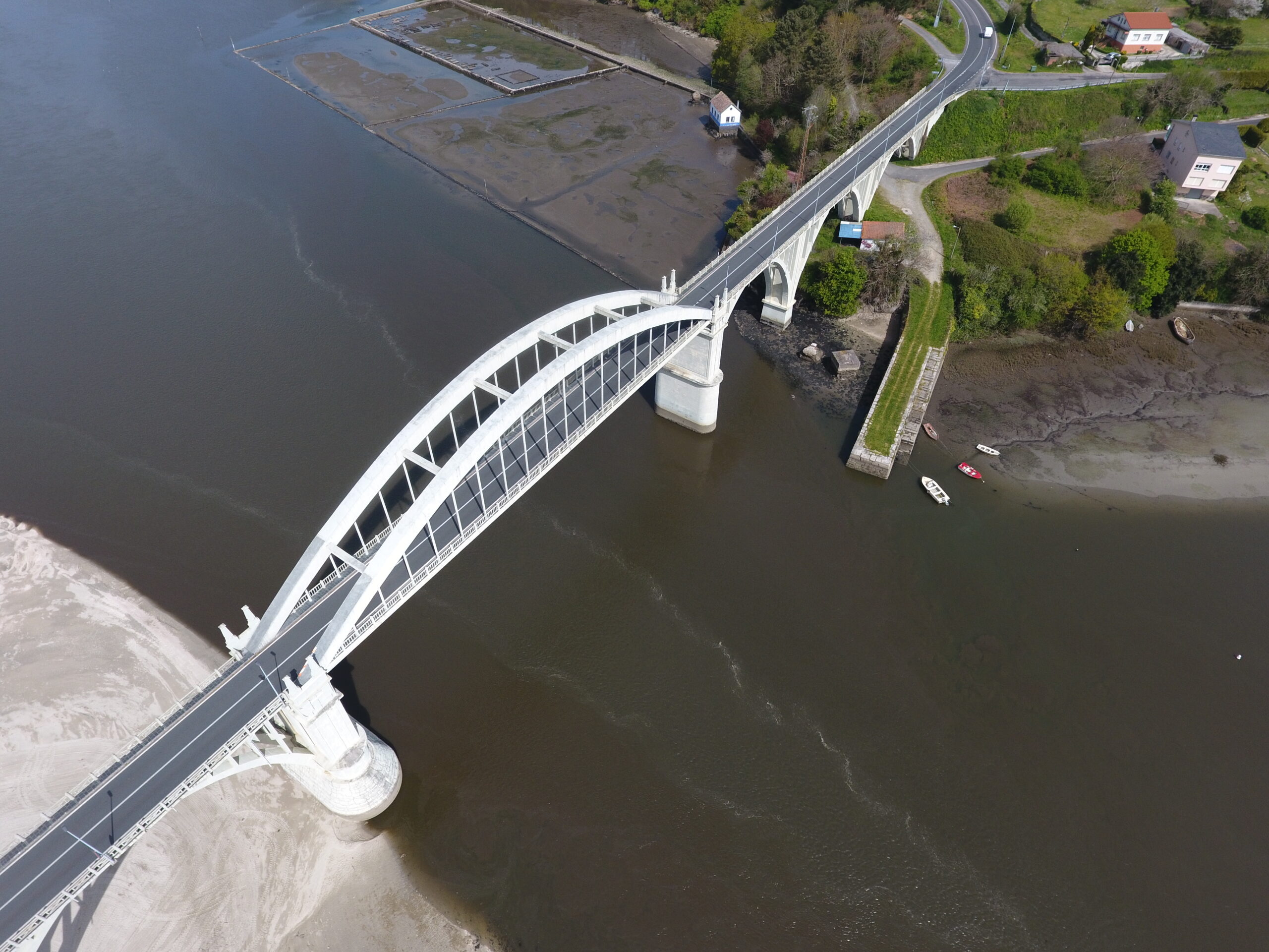
The Pedrido Bridge is over the Betanzos estuary and connects both banks since its construction (1939 and 1942).
The time wasted by bordering the estuary in a small boat (since an 8-kilometer turn was necessary) and the limitation in the number of goods one could transport by barge limited the area's development for many years, making the construction of a bridge to link the two banks essential. This construction began in 1920, stopped for several problems, including the outbreak of the Spanish Civil War.
Different engineers and companies participated in its construction. The works resumed in 1939, followed the project of the engineer César Villalba although he did not manage to finish it. The most representative element of the bridge is the grand central arch of 75 meters with 12.50 meters of permissible deflection with two joints and a lower deck hung by spaced pendants at 3.65 meters, a work of Eduardo Torroja Miret, who was the same engineer that designed and finished the project between 1941 and 1942.
The official inauguration of the bridge was on April 15, 1943, and constituted a significant news piece, as evidenced by its inclusion in both the written press and the famous NO-DO.
As previously mentioned, the bridge helped improve the communities of both sides of the estuary and the communications between the A Coruña and Ferrol.
To learn more
The area of O Pedrido is at the confluence of the bridge and the beach of the same name.
The Pedrido beach is a semi-urban beach, rectilinear, 700 meters long, with fine white sand, calm waters, and moderate waves that offers stunning views of the Betanzos estuary.
O Pedrido belongs to the biosphere reserve called Las Mariñas Coruñesas e Terras do Mandeo, declared a reserve on May 28, 2013. It covers 17 municipalities in the A Coruña, Betanzos, and Terra de Melide Counties, with 113,970 hectares and an approximate population of 195,000. It is also a Site of Community Interest (SCI) and belongs to the Natura 2000 Network.
In the marshes that form the O Pedrido beach, the Mandeo and Mero rivers are home to little egrets, herons, and common kingfishers. Yellow-legged gulls and spectacled terns reach concentrations of 3,000 or 4,000 specimens, mixed with some lesser black-backed and black-headed gulls, in the low tide of Pedrido and Ponte do Porco. In O Pedrido, there is an abundance of Eurasian whimbrels and Eurasian curlews.
The estuary is home to clams, cockles, mussels, European bass, flathead grey mullets, weevers, Atlantic bonitos, sturgeons, sardines, European anchovies, and European congers, among others.
The O Pedrido beach is on the left and right edges of the bridge with the same name. On one side, it is worth noticing the broad sandy stretch, and on the other side, the recreation zones and services offered to tourists visiting the area.
The Pedrido Bridge is an arch bridge that crosses the Betanzos estuary, joining the Bergondo and Paderne municipalities. The bridge was public work, built between 1939 and 1942.
Until the bridge construction, the neighbors transported the selling merchandise by small boat, limiting the cargo to a specific amount of goods or losing precious time for going around the estuary and passing through the city of Betanzos. Therefore, the bridge construction was a before and after, improving communications, building methods, and the region and surroundings.
The first person in charge of the project was the engineer Luciano Yordi, but little was known about his ideas for the bridge, only that it would be about thirteen meters high; however, soon after the start of the works, the neighborhood protests stopped the project.
In 1928, César Villalba Granda was the engineer appointed to design the project, but it took him five years to commence the works, causing the Zamora - A Coruña railroad construction to take away the significance he deserved for his project.
The construction company, hired in the first place, was replaced in 1935 by an Italian one, who had to assume the mistakes made by the previous one and had to destroy the bridge arch to build and raise a new one.
In 1936, the construction was constant, to the point where they raised the metallic armor, but the sudden Civil War outbreak led to the suspension of all works.
In 1940, when the works resumed, it was necessary to change the reinforcement for one with laminated profiles, scheduling the bridge completion for that same year. However, the Spanish autocracy prioritized the Catalan bridges reconstruction, demolished in the Civil War, delaying, once again, the work on this bridge until 1943.
Eduardo Torroja Miret, one of the renowned civil engineers of his time, was in charge of finalizing the bridge design, following the layout of the engineer César Villalba Granda. In most of his works, Torroja was a renovator for applying reinforced concrete to his architectural structures and revolutionary forms never used before.
He designed the completion project between 1941 and 1942, building a tensile arc of 75 meters with 12.50 meters of permissible deflection, two joints and a lower deck hung by spaced pendants, and the board as a continuous wrought of 3.65 m, except for the two edges of 2.83 supported on transverse beams at their ends of the arching spans. The arch comprises two central ribs of variable edge beams and spring lines of uniform length. The engineer established a principal work by using reinforced concrete, and after the termination of the bridge's construction, it improved interregional communications and between A Coruña and Ferrol, further implemented with the development of the AP-9 highway.
As reported by the media of that time, the bridge inauguration was on April 16, 1943. Between the years 2013 and 2014, it underwent adaptability improvements on its outer layers, and its structure has remained in an excellent condition of preservation.
To know it better
Bergondo is a Galician municipality located in the A Coruña province in the Betanzos estuary bordering the municipalities of Sada, Cambre, Abegondo, Betanzos, and Paderne.
On one part of the coast of the Betanzos estuary is O Pedrido, a protected area and recognized as a Site of Community Importance (SCI). Its beach is at the mouth of Mandeo River. It has calm waters and dark sand, and it is 500 meters long, 40 meters wide, and dependent on the tide.
The well-known Pedrido Bridge, built between 1939 and 1942, joins the banks of the Betanzos estuary. Construction work on the bridge was interrupted on many occasions, which meant that it was necessary to continue crossing the Betanzos estuary by boat, which meant a considerable loss of time and limited the number of goods transported.
César Villalba Granda and Eduardo Torroja Miret designed the bridge project and the company Ricardo Barrredo S.A. carried out its execution. The bridge is more than 250 meters in length and has three distinct sections: the first, a deck supported by ten double arches, second, a large double-arch hold by forty hangers, and third, a set of three double concrete arches as support for the remaining meters of the deck.
Gallery


Location
- Town
- O Pedrido
- Municipality
- Bergondo
- Province
- A Coruña
- Country
- Spain
The asset
- Type
- Bridge
- Eco-destination
- Rías de Ares y Betanzos
- Environment
- Rural
- Relevance
- Regional
How to get there
- Access
- By sea
- Distance
- 7,100 km
The visit
- Accessible
- No
- Parking
- No
- Signposted
- Yes
Coordinates
- Latitud
- 43.32791071250558
- Longitud
- -8.209849106866875