


Vigo. Estay Cape. Mine and dump
About this heritage
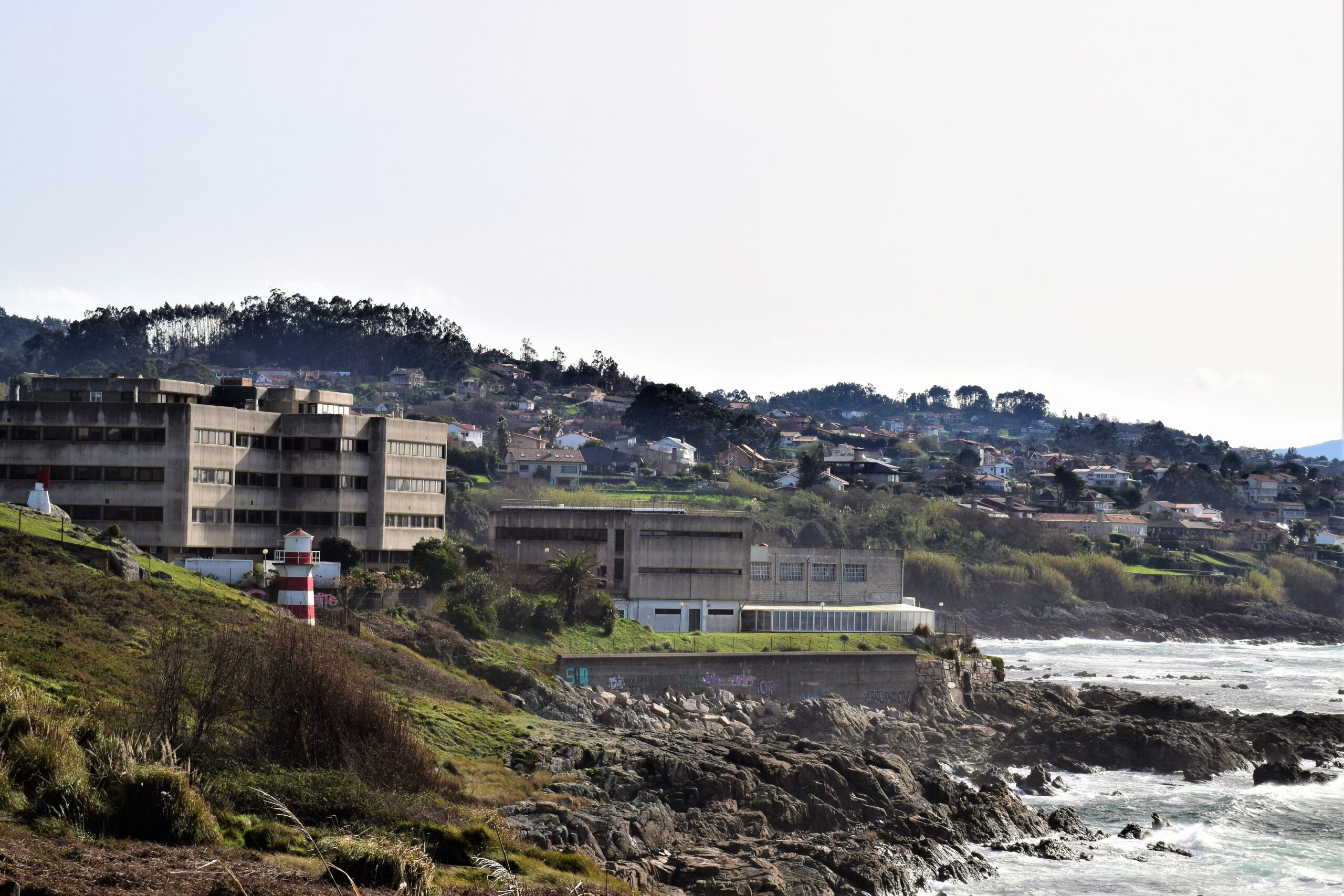
Estay cape is one of the most western points of the Vigo City Council. It is located in Oia´s parish and in recent years is characterized by the urban pressure by the coast. Its orientation to the west and its privileged location towards the exit of the estuary, make this point, an unbeatable place in terms of views to the ocean and the Cíes islands.
In addition to the urbanizations, the Oceanographic Institute of Vigo is located in the same cape, also a radio lighthouse that form a set of signs, along with another one with the same characteristics; located a little bit further in land and attached to the known as “Autovía” (Dual carriage way); which links Vigo and Baiona along the coast. The San Miguel de Oia football field is very close to the cape.
However, Estay cape stands out for being one of the oldest geological created areas in the Galician Community. There we come across a small mine that constitutes a unique geoarchaeological site for several reasons: the first of them places both the dump and the mined mineralizations in sight; by erosion effects. Something unusual, as well as having a complete stratigraphic sequence, which constitutes the cycle of the mine; from its beginnings to its abandonment. This dump is fossilized at the beach level, which means that the site is not only for great archaeological interest, but also environmental. A real reference for the reconstruction of the sea level variations. The discovery of numerous coals on the beach and on the base of the dump date from the opening of the mine, something exceptional. It is possible that these coals could confirm the use of fire to break the rocks, as Plinio exposed. According to some documents provided by scholars on the subject, sending a sample of carbons from the debris pile´s base to be dated, the result is more than surprising: more than 43.500 years, which means that it has been outside the application range of the Carbon 14 technique.
To learn more
Estay cape is the starting point for a unique geological, archaeological and natural vestige, which will be repeated along the coast to the north and south along the estuary. It is the reference point for the variations of the sea level reconstruction, some of the beach levels that continues towards the outside of the estuary until Praia D´Abra (Nigrán); and for the interior until the beaches of A Fonte, between Samil and Alcabre.
In this cape we find a large quantity of coals located in the fossil beach, as well as a dump discovered by the Phoenicians in their passage along the Atlantic coasts. This is a small ancient mine that constitutes a unique geoarchaeological site of this kind. Although the old deposit-mine is a very singular place, the fossil beach levels of its base are relatively common and, in fact, it can be followed to the outside of the estuary in Praia D´Abra, and to the east intermittently along several hundred meters around the Estay cape dump.
The site is structured into three large levels or stratigraphic sequences, which from the wall to the ceiling are divided into: fossil beach level over the rocky substratum. In the lower topographical areas, this level presents a positive sequence (decreasing grains towards the roof) formed by a boulder conglomerate with rounded gravel laminations above and sand beaches a little bit above. This sand beaches lose sphericity towards the ceiling and with topographic height, being in some occasions indistinguishable of a granite sand. Cementation is the typical of iron oxides. Dump level. It presents itself dissident over the fossil beach and locally erosive. To the east of the mine quartz dike, several layers can be distinguish forming a large, pile-supported edge deposit.
Approaching, we see clasts and quartz slabs of all sizes, completely fractured and without any sight of weathering. The dike has been completely crushed. As for its dating, having chosen a sample of coals from the pile of rubble, we go 43.500 years back, outside the application range of the Carbon 14 technique. What might be questionable is whether the fossil beach is “Holocena” (less than 10.000 years ago) or “Eemiense” (last interglacial, about 120.000 years ago).
From a geological point of view, nature and water could provide a granulometric selection and internal arrangement of the tank. If the age was Holocene, it would remain to be verified that the mineralization that accompany the quartz dike is - in effect – of mining interest. On the contrary, if no mineralization appeared, the hypothesis of the mine would remain lame, in spite of age.
To know it better
As we already know, Vigo and its surroundings have charming coastal places with a lot of history. In this case, we talk about Estray cape, one of the most western points of Vigo City Council, located in Oia´s parish.
In the same cape it is located the Oceanographic Institute of Vigo which makes the place a site of interest, a lighthouse, furthermore when we visit the area we can enjoy beautiful views thanks to its cliffs. On the other hand, since not so many years, we can observe that it has a unique geoarchaeological site that gave rise to a pre-roman era mine known as “La escombrera minera de Cabo Estay” (mining dump of Estay Cape).
The different investigations have come to the conclusion that, in part of the Estay cape cliffs, an exploitation was carried out to get different minerals and it is what we know today as “Estray cape Mine”
Gallery

Location
- Town
- a pesar de la edad., arqueológico y natural único, Cabo Estay supone el punto de partida de un vestigio geológico, completamente fracturados y sin señal alguna de meteorización. El dique ha sido completamente machacado. En cuanto a su datación, de hecho, el nivel de playa fósil de su base es relativamente común y, entre Samil y Alcabre.En Cabo Estay hallamos una gran cantidad de carbones a techo de playa fósil, fuera del rango de la aplicación de la técnica del Carbono 14. Lo que podría ser cuestionable es si la playa fósil es Holocena (de hace menos de 10.000 años) o Emiense (último interglaciar, habiendo escogido una muestra de carbones de la pila de escombros, hace unos 120.000 años).Desde un punto de vista geológico, hacia el sur, la hipótesis de la mina seguiría coja, la naturaleza y el agua aportarían una selección granulométrica y ordenación interna al depósito. Si la edad fuera holocena, nos remontamos 43.500 años atrás, que de muro a techo se dividen en: nivel de playa fósil sobre el sustrato rocoso. En las zonas topográficamente más bajas, que se repetirá a lo largo de la costa, quedaría por comprobar que las mineralizaciones que acompañan al dique de cuarzo son -en efecto- de interés minero. Por el contrario, si no apareciesen mineralizaciones, unos niveles de playa que continúan hacia el exterior de la ría hasta Praia D´Abra (Nigrán); y por el interior hasta las playas de A Fonte, vemos los clastos y lajas de cuarzo de todos los tamaños, y el norte por la ría. Es el punto de referencia para la reconstrucción de las variaciones del nivel del mar
- Municipality
- Vigo
- Province
- Pontevedra
- Country
- Spain
The asset
- Type
- Cape
- Eco-destination
- Ría de Vigo
- Environment
- Rural
- Relevance
- National
How to get there
- Access
- By sea By land
- Port
- Puerto de Canido
- Distance
- 1,9 km / 6 minutos en coche
The visit
- Accessible
- No
- Parking
- No
Coordinates
- Latitud
- 42.18449900
- Longitud
- -8.81352600