
Ría de Vigo. Scuba Diving. South Island Cíes
About this heritage
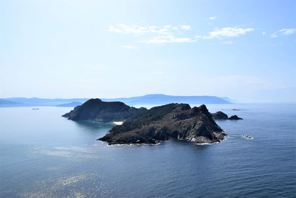
The Cíes Islands are three; two of them connected by a dike and a sandbar, although not always. Four or five times a year, the sea divides the two central islands and the third: San Martiño, which remains completely unknown to everyone. Most visitors have strolled at some point along the sands of Rodas beach, but very few have been able to land on the South Island and even fewer have walked inside it; since to land, it is necessary to have a yacht and a boat to reach its beach, due to the lack of docks, except for one service dock of the Port Authority and the Illas Atlánticas National Park, which leads to Cabo Bicos. Inside the island there are no paths or hardly any tracks, except for the access to the lighthouse and a short trail on the beach that runs towards the remains of a mill. Both slopes, one facing the ria and the other the Atlantic, have steep hillsides, dense vegetation, gorse, and trees. The island is a refuge for seagulls and cormorants, forbidden to humans, except for its 500-meter beach. There you find everything San Martiño offers to the few visitors: a sandy beach, two houses, one of them inhabited, and the remains of a mill and a salting factory that was exploited during the 20th century. Regarding the zoology of San Martiño, it should be noted that it was threatened by the continuous presence of American mink that swam from Baiona, where there was a fur farm from which some specimens escaped. Under the waters of the Cíes Islands, the situation changes. Different habitats full of life have been created. The various types of substrates that make up the seabeds of these islands are bathed by waters influenced by the warm surface Gulf Stream, softening their temperature. Also by the winds blowing from the north during spring and summer. These latter displace surface waters, allowing the rise of cold deep waters rich in nutrients - upwelling -. Added to this is the river input from the rías that conditions salinity, sediments, and organic matter. Thus, rocky bottoms with forests of brown algae occur, as happens in the San Martiño Wall, a calmer area with only 10 meters depth. Here we find a large group of kelp: algae that can reach more than 2 meters, firmly anchored to the bottom, waving gently with the current. Long and thick blades that intertwine like a dense forest, closing the passage between them. However, the underwater bottoms of the Cíes not only harbor fauna and flora but also historical remains of battles that took place on these coasts since their formation. This is the case of the Nazi submarine found off the coast of the South Island of San Martiño. A German WWII submersible. And although Vigo was not an official base for Nazi submarines, it was a refuge for their military, spies, and crews who, for example, used the German School, located on the current Pi y Margall street, as a place of rest and transit. On the other hand, it is confirmed that several Nazi submarines sank between Cíes and La Guardia during the conflict.
To learn more
Being on San Martiño produces a curious sensation of solitude (real), as there is usually no one there, except for the few visitors who come down to the beach on their yachts, being just a few kilometers from the city. The Playa de San Martiño takes its name from the island to which it belongs, triangular in shape and wider than those to the North, separated from each other by the Freu da Porta channel. It has a shell shape and is set in a pristine environment. Even more so is Cabo Bicos, perhaps the key to everything. Researchers have concluded that the name of the tip where a lighthouse stands was originally Bico and has nothing to do with the Galician word for "kiss," but rather with a possibly Celtic or at least pre-Roman origin. For a time it was believed that in the itinerary "Per Loca Marítima" there appeared a Vicus Spacorum which would be the "village of the Spacos," the current Vigo. Some historians like Crespán disagree, emphasizing that 28 castros have been found in the city of Vigo, one of them - the current Monte do Castro de Vigo - was called Bico, and served as a collective name for the others. In that area there would have been a tribe, the Caporos, and from there the name "Vicos Caporum" could have come. The evidence seems compelling and points to a direct relationship between Vico and Cabo Bicos due to the alignment of the Castro with the South Island. So the city should owe its name to the promontory of the Cíes and not to a Vicus, a village. A combination of factors determines the richness and biodiversity of the Illas Atlánticas National Park. Some of these habitats can be explored through diving. One of the most special seabeds in these waters is located at the San Martiño Wall, a calmer area with only 10 meters of depth. Here we find a large group of laminarias: algae that can reach more than 2 meters, firmly anchored to the bottom, waving gently with the current. Long and thick blades that intermingle like a dense forest, closing the passage between them. These brown algae are: Saccorhiza polyschides, Laminaria ochroleuca, and Laminaria hyperborea. They inhabit rocky bottoms providing habitat and sustenance to other species. Some of them form an understory, the epiphytes. And in search of refuge, polychaete worms, crustaceans like spider crabs and velvet crabs, or mollusks like limpets or sea ears. Areas where the substrate is more vertical favor the appearance of caves and crevices
To know it better
shelter for crinoid and ophiuroid echinoderms. Soft corals, gorgonians, and sponges. The octopus will also take refuge in these small caves. A habitat of spectacular richness and beauty, which has suffered the impact of strong and continuous storms in recent years. The strong swell and an excess of freshwater input due to heavy rainfall have caused the loss of part of these communities on the northern coast of Spain, a possible consequence of climate change. In 2013, and according to eyewitnesses, an expedition of experts and civilian and military scientists aboard the oceanographic vessel Ángeles Alvariño discovered south of the Cíes Islands a historic wreck that "due to its relief and dimensions" could be one of those German submarines from World War II. The Ministry of Defense did not dare to deny the existence of "Ofión," a supposedly classified secret project aimed at locating galleys or sunken vessels in deep waters. The alleged discovery was made during three days of navigation that the oceanographic vessel carried out on August 2, 3, and 10 through the Ría de Vigo, near the Cíes Islands. At a point located 50 miles from these last islands, the sonar captured a series of surprising images: where military documentation pointed to the possible existence of the wreck of the legendary 18th-century galleon - Santo Cristo de Maracaibo -, now the images depicted what appeared to be a Nazi submarine. There is abundant information showing that, although Vigo was not an official base for Nazi submarines, it was a refuge for their military, spies, and crews. On the other hand, it is confirmed that several Nazi submarines sank between Cíes and La Guardia. Among them, the U-566 and U-134 submarines, both model VIIc measuring 67.1 meters in length and 6.18 meters in beam, capable of descending up to 200 meters deep. The most likely is that it was the U-566, which just after departing from France towards the Mediterranean on its fifteenth patrol, was spotted on October 24, 1943, by a British Wellington bomber that dropped six charges causing significant damage and preventing it from submerging. Its captain, Hans Hornkohl, ordered it to be scuttled and the crew jumped onto several inflatable rafts. Subsequently, the 49 officers and sailors were rescued by the fishing boat Fina which, ironically, took them to Vigo where they were handed over to the German consul who immediately arranged their return to France. Officially, the U-566 sank at 41º12'N - 09º 31'W.
Gallery
Location
- Town
- Si
- Municipality
- Vigo
- Province
- Pontevedra
- Country
- Spain
The asset
- Type
- Island
- Eco-destination
- Ría de Vigo
- Environment
- Located in the province of Pontevedra, and more specifically in the Ría de Vigo, the Cíes Islands have nine beaches of fine white sand and crystal-clear waters. Triangular in shape, the Isla de San Martiño is one of the widest of the Cíes. Currently, we can observe remains of our Galician history such as the hermitage of San Martiño or the pieces of Muíño do Limpiño and reach the highest point of the South island, Monte Pereira. The marine environment is one of the attractions we can enjoy on the island. In fact, the Cíes form one of the richest ecosystems on the Galician coast, as well as having a large amount of brown algae and corals. Its seabeds are formed by four layers. The first contains sand, while the second has gravel (small stones). The third is formed by Maërl (algae) and the fourth by rocky elements. On the other hand, forests also appear under the sea, called laminaria forests, which are composed of large brown algae.
How to get there
- Access
- By sea By land
- Distance
- 0,3 km
The visit
- Visitable
- Yes
- Accessible
- No
- Parking
- No
Coordinates
- Latitud
- 42.206434
- Longitud
- -8.907955